Training Tips for Hiking the Mt. Timpanogos Summit Trail
- Alicia Filley
- Jul 24, 2021
- 4 min read
This strenuous hike (rated difficult) has nearly every kind of trail environment possible. Therefore, you'll want to make sure you're well prepared! Read on for trail details and training tips.
There are two ways to reach the summit of Mt. Timpanogos, the second highest mountain in Utah. One is from the Timpooneke Campground and the other is from Aspen Grove, both roughly 14 miles round trip. The two summit trails which meet up at the saddle are especially busy on weekends, with lots of hikers starting in the dark early-morning hours to summit by sunrise. By 6:00am the parking lot at Timpooneke was full on this Saturday in July of 2021, so we chose to start at Aspen Grove. Know that parking is an issue at both places, but Aspen Grove has more areas for overflow where you won't be ticketed. Ticketing and towing are frequent for illegal parkers at Timpooneke. Be sure to pay the $6 usage fee for the Uinta National Forest recreation are either in the envelopes provided at the trailhead or online.


From this trailhead, the summit is a steep 7 mile hike that climbs over 5,000 feet in elevation. This trail has it all: wooded trails, waterfalls, a babbling creek, flower strewn meadows, a glacial lake, boulder fields, a rocky ascent with dizzying views, and usually snowfields to cross. Due to the extensive drought and oppressive heat wave, the snow had nearly all melted by mid July. There was one slushy patch that was easily walked around before the saddle approach. Talk with park rangers and read trail reports before attempting this summit any other time as crampons are often necessary. This trail is open year-round but attempting any time outside of late spring to fall requires experience with winter and ice climbing conditions.
The first mile of this trek is partly paved but steep nonetheless. If you start after sunrise on a weekend, you'll encounter swarms of college kids plowing by you on the way down. Let the etiquette lesson go and take advantage of the rest as you plow upward on through the forested and partly rocky path toward the first waterfall. Water on the first half of the trail is plentiful but needs treatment or filtering. After Emerald Lake there is a trailside creek that will be your last chance for water before the summit.


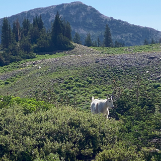
Wildlife is plentiful on the trail. Mountain goats are easily spotted and don't mind the traffic. Other animals you might see are deer, big horn sheep, marmots, and eagles. These critters are used to humans so don't set your backpack down unattended in the meadows or the chipmunks will invade looking for a snack. Bears and cougars roam the area, but with all the summertime human traffic, aren't probably something you'll need to worry about. After you cross the meadow, which is usually awash in wildflowers, and catch a glimpse of Emerald Lake, you'll pass the rescue shelter. The amazing volunteers with the Timpanogos Emergency Response Team (TERT) set up here on the weekends. We saw the team in action as we came up upon a rescue in the boulder field and passed another hiker already in the shelter. Both were air-rescued a bit later, showing that while heavily trafficked, this trail is difficult and challenging even for experienced hikers. For updated weekend trail conditions, follow the TERT team's Twitter. Cell phone reception is good along the trail and at the summit, so be sure to have emergency contact numbers programmed in your phone.


Trail and training tips:
This strenuous hike (rated difficult) has nearly every kind of trail environment possible. Therefore, you'll want to make sure you're well prepared. If you're not used to altitude, the summit is at nearly 12,000 feet so you'll want to take a few days to acclimate before ascending. In addition to the 10 essentials, make sure you've got enough food and water or a means to filter water along the way. My Garmin estimated I burned 2000 calories on this hike, which for me meant I needed frequent snacks along the way. Poles are helpful on the way up, but nearly essential on the way down as you descend the scree incline between the boulder field and the saddle. Take a rest at the saddle before you begin the climb to the summit. If you find yourself getting dizzy, take a break. Keep your eyes ahead of you on the trail and not on the nearly 360 degree view around you. There's a small surveyor's hut at the summit where you can sign the wall or the log book. The day we arrived it was so crowded for safety's sake we tagged it and quickly moved on back down the trail. Weather conditions change quickly at altitude so you'll want rain and wind protection in case it's chilly, gusty, and wet at the top. We were graced with a beautiful clear day without any wildfire smoke or haze.


Training for this hike should include endurance training. While there are record-setting trail runners and locals who frequent the mountain who summit and descend in just a few hours, it was an all-day affair for our group as we stopped to enjoy views, watch goats, snack in the shade along the meadows, and cool ourselves in the waterfalls. Unless you're trying to PR your climb, you need to have the fitness to be on your feet for at least six hours and probably more.
Your calves will be shredded after the climb up so you'll want to include calf raises in your workout routine along with loaded squats and step-ups. Pro tip: when climbing, let your big powerful leg muscles do the work by getting off of your toes and stepping up while hinged forward at the hips and heels down. This relieves the smaller calf muscles from having to do all the heavy lifting.
Since what goes up must come down, you'll want to train your quads eccentrically to handle the descent and minimize next-day soreness. My favorite exercises for this are tempo squats with a count of four while lowering or BOSU-ball step-overs. You don't need a lot of weight for either but you'll want to do three to four sets to fatigue.
Want a personalized training plan to get you fit for summiting Mt. Timp or conquering your dream trail? Message me for more info on how The Healthy Hiker program can get you feeling stronger and more confident on the trail!